The planet Earth
Our planet is called the Earth.
It is placed in the Solar System.


Our Solar System is a collection of planets, moons, asteroids and comets.


There are eight planets: Mercury, Venus, Earth, Mars, Jupiter, Saturn, Uranus and Neptune.

All of them revolve around the Sun, our star.

Representations
There are different representations of the Earth.
For example: globes and maps (atlas).


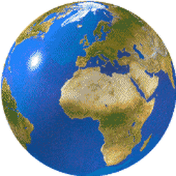
GLOBES
A globe is a spherical representation of the Earth in 3D.
It has lots of imaginary lines. These lines help us locate different places on the Earth surface.


-
The North Pole is the most northern point of our planet.
-
The South pole is the most southern point of our planet.
-
The Earth’s axis goes from the North pole to the South pole, through the centre of the Earth.
Types of imaginary lines
The Lines of longitude or Meridians, are the lines running from the north to the south around the Earth.

The most important meridian is Greenwich. It divides the Earth into the Eastern and Western hemispheres.

The Lines of latitude or Parallels, run from the east to the west across Earth.

The most important parallel is the Equator. It divides the Earth into the Northern and Southern hemispheres.

Now you can take a look at this video! =)
MAPS
Maps show our planet as a flat surface.

Maps are smaller representations of a place, so they have a scale (for example 1cm=100 km).


Different maps show different information. Maps can represent the world, a continent, a country or a region.
Map of a continent: Europe

Map of a country: Spain


Map of a region: Madrid
Types of maps

Political maps show different countries and important cities.
They have different colours and lines to divide the different places.

Physical maps use different colours to show different areas of natural features such as mountains, rivers and lakes.

Thematic maps show specific information
such as the weather, roads, or other topics in an area.